


The Desert Jet Chase – Sky Adventures Part 8
Sky Adventures
with Safe Fly Aviation
The Desert Jet Chase
Desert Ace and Compass navigate NaviWing through sandstorms and bandits while learning about modern navigation systems!

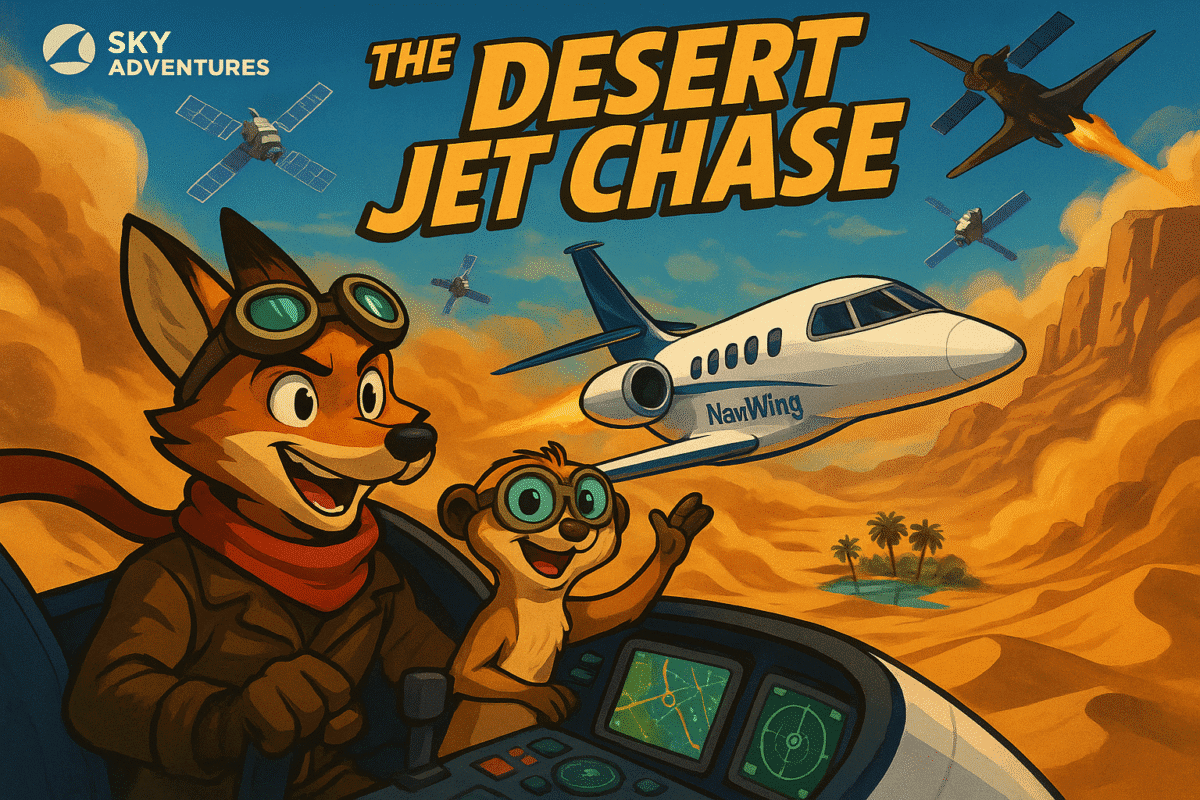
Meet Desert Ace and Compass the meerkat navigator with their advanced NaviWing business jet, ready for the ultimate desert navigation challenge!
Meet Our Desert Navigation Heroes
Desert Ace
Experienced pilot specializing in desert navigation and challenging terrain flying. Wears signature desert goggles and has mastered the art of instrument navigation through sandstorms.
Compass the Meerkat
Brilliant navigator who understands GPS satellite systems, flight management computers, and traditional navigation methods. Always carries detailed charts and loves explaining navigation technology.
The Secret Mission Begins
The scorching desert sun was painting the horizon in shades of gold and orange when Desert Ace received the most challenging mission of his career. He was a seasoned pilot with sun-weathered hands, desert goggles that never left his face, and a khaki flight suit that had seen countless adventures across the world's most remote locations.
"Compass, old friend," Desert Ace called to his remarkable navigator, a clever meerkat who wore a tiny pilot's cap and carried the most advanced navigation charts in the region. "We've got ourselves a proper desert crossing to make."
The mission briefing had been crystal clear: transport vital archaeological research data from the Remote Desert Research Station to the International Museum before sunset. The catch? The direct route crossed 800 kilometers of the most treacherous desert on Earth—complete with unpredictable sandstorms, shifting magnetic fields that confused traditional compasses, and rumours of aircraft bandits who prowled the skies looking for valuable cargo.
Meet the Navigation Masters
Inside NaviWing's advanced cockpit, Compass explains the sophisticated navigation technology that will guide them safely across the desert.
As they performed their pre-flight inspection, Compass explained the sophisticated technology that would guide them safely across the vast desert expanse.
"NaviWing is equipped with triple-redundant GPS systems," Compass said proudly, pointing his tiny paw at the aircraft's antenna array. "We've got primary GPS, backup GPS, and an inertial navigation system that works even if all satellite signals are blocked."
Navigation Technology Explained
- GPS (Global Positioning System): Uses satellites 20,000km above Earth to provide precise positioning
- Inertial Navigation: Uses gyroscopes and accelerometers to track movement from takeoff
- Flight Management System: Computer that calculates optimal routes and fuel consumption
- Weather Radar: Detects storms and turbulence ahead of the aircraft
Into the Desert Unknown
As NaviWing climbed smoothly away from the desert airfield, the landscape below transformed into an endless sea of rolling sand dunes punctuated by rocky formations that looked like ancient monuments to time itself. The GPS display showed their position as a moving blue triangle on a detailed map that updated every second.
"First navigation lesson, Compass," Desert Ace announced as they reached their cruising altitude of 11,000 metres. "GPS stands for Global Positioning System. It works by receiving signals from at least four satellites orbiting Earth at 20,000 kilometres above us."
Educational diagram showing how GPS satellites communicate with NaviWing to provide precise navigation anywhere on Earth.
Compass pulled out a miniature diagram that showed satellites beaming signals down to aircraft. "Each satellite broadcasts its location and the exact time," he explained enthusiastically. "NaviWing's GPS receiver calculates how long those signals take to reach us, and from that information, it determines our precise position!"
The Sandstorm Challenge
Fifty kilometres into their journey, Compass's sharp meerkat eyes spotted trouble on the horizon. "Desert Ace! Massive sandstorm at two o'clock! It's moving directly across our flight path!"
NaviWing navigates through a massive desert sandstorm using only instruments, demonstrating how modern navigation systems work even in zero visibility conditions.
The storm was a towering wall of swirling orange and brown dust that reached up to 4,000 metres into the sky. Lightning flickered within the churning mass, and the weather radar screen painted it in threatening shades of red and magenta.
"Right, this is where our navigation systems really prove their worth," Desert Ace said calmly, his hands steady on the controls. "We can't see anything in that storm, but our instruments will guide us through safely."
As NaviWing entered the sandstorm, visibility dropped to zero. The aircraft bucked and rolled in the turbulent air, but Desert Ace maintained precise control using only his instruments. Outside the windows, everything was a swirling brown chaos, but inside the cockpit, the navigation displays continued showing their exact position and heading.
The Bandit Encounter
As they continued across the vast desert, Compass suddenly spotted something alarming on the traffic display. "Desert Ace! Three aircraft approaching fast from the southwest! They're not responding to radio calls and they're not on any flight plan!"
An exciting aerial chase as NaviWing uses superior navigation systems to outmaneuver bandit aircraft through desert canyons and rocky formations.
Desert Ace checked the traffic collision avoidance system, which painted three red symbols converging on their position. Through the windscreen, he could see three old propeller aircraft painted in desert camouflage, clearly trying to intercept NaviWing.
"Aircraft bandits," Desert Ace confirmed grimly. "They're after our archaeological research cargo. Time for some evasive navigation, Compass!"
Using NaviWing's superior speed and modern navigation systems, Desert Ace began a series of precise course changes. The GPS allowed him to navigate through a maze of rocky canyons and around towering mesa formations that would be invisible on older navigation systems.
Navigation Safety Systems
- Traffic Collision Avoidance: Detects nearby aircraft and warns of potential conflicts
- Terrain Awareness: 3D mapping of ground obstacles and safe flight paths
- Weather Radar: Shows storms, turbulence, and dangerous weather ahead
- Multiple GPS Systems: Backup navigation if primary systems fail
The Oasis Landing
As they approached their destination—a remote desert research station built around a natural oasis—the navigation systems guided them to a perfect approach. The GPS showed their position relative to the runway with metre-level accuracy, while the radar altimeter provided precise altitude information.
Mission accomplished! NaviWing lands safely at the beautiful desert oasis research station, guided precisely by advanced navigation systems.
"There it is, Compass!" Desert Ace called out as the oasis came into view. "Palm trees, crystal-clear water, and a proper runway. Navigation systems brought us here precisely as planned, despite sandstorms, bandits, and 800 kilometres of trackless desert."
The landing was smooth and precise. As NaviWing rolled to a stop beside the oasis, archaeologists and researchers rushed out to collect their precious cargo. The mission had been a complete success.
Dr. Sandstone, the lead archaeologist, shook Desert Ace's hand warmly. "Remarkable flying! Without your navigation expertise, this research data might never have reached the museum. You've helped preserve history itself!"
The Technology Behind the Adventure
As they refueled NaviWing for the return journey, Compass was still fascinated by all the navigation technology they had used. "Desert Ace, how did pilots navigate before GPS?"
"Brilliant question, my friend," Desert Ace replied, settling into teaching mode. "Early pilots used dead reckoning—calculating their position based on compass heading, airspeed, and time flown. They also used celestial navigation, taking position fixes from the sun and stars with a sextant."
Compass pulled out his charts, which now seemed almost magical compared to the old methods. "But those techniques weren't very accurate over long distances, were they?"
"Quite right," Desert Ace confirmed. "Navigation errors of 50 kilometres or more were common. That's why so many early desert flights ended in tragedy. Modern GPS navigation is accurate to within a few metres anywhere on Earth."
The Safe Return Home
The return journey was smooth and uneventful, with NaviWing's navigation systems guiding them safely around weather systems and directly to their home base. As they descended through the evening air toward the desert airfield, both Desert Ace and Compass reflected on their successful adventure.
"You know, Compass," Desert Ace said as they taxied to their parking spot, "this mission showcased everything wonderful about modern aviation navigation. We crossed 1,600 kilometres of desert, navigated through sandstorms, evaded bandits, and delivered our cargo safely—all because of the remarkable navigation technology in business jets like NaviWing."
Compass carefully stored his navigation charts and switched off the GPS displays. "It's amazing how satellite technology, radar systems, and flight computers work together to make flying so much safer than it used to be."
As the sun set over the desert airfield, painting the sky in brilliant oranges and purples, Desert Ace and Compass prepared NaviWing for her next adventure. The world was full of challenging destinations, and with their advanced navigation systems, no place was too remote to reach safely.
"Ready for tomorrow's mission, Compass?" Desert Ace asked.
"Always ready to navigate, Desert Ace!" Compass replied with a grin.
Aviation Lesson for Young Readers
Modern Navigation Systems make flying safer and more precise than ever before!
GPS Navigation
- • Uses 24+ satellites orbiting Earth at 20,000km altitude
- • Provides position accuracy to within a few metres
- • Works in all weather conditions, day and night
- • Calculates position using signals from 4+ satellites
Business Jet Features
- • Multiple GPS receivers for redundancy
- • Weather radar to detect storms
- • Terrain awareness systems
- • Traffic collision avoidance
Safety Benefits
- • Multiple backup systems prevent errors
- • Metre-level accuracy over vast distances
- • All-weather operations capability
- • Automatic route optimization
Desert Flying Facts
- • No visual landmarks for hundreds of kilometres
- • Sandstorms can reduce visibility to zero
- • Navigation equipment must work in harsh conditions
- • GPS works perfectly in desert environments
Navigation Then vs Now
Before GPS:
- • Navigation errors of 50+ km were common
- • Used compass, stars, and dead reckoning
- • Many flights ended in tragedy
With Modern GPS:
- • Accuracy to within a few metres
- • Safe navigation in any weather
- • Automatic collision avoidance
Sky Adventures Series
Part 1: Runway Mystery
Part 2: Helicopter Rescue
Part 3: Midnight Charter
Part 4: Cargo Bear
Part 5: Air Show Challenge
Part 6: Turbo's Jungle Adventure
Part 7: SkyFox Air Ambulance
Part 8: Desert Jet Chase
Join Desert Ace and Compass as they discover how modern navigation technology makes flying safer and more precise than ever before!
