Safe Fly Aviation + xChain Smart Control Tower for modern vertical flight operations
Smart CT is a connected control and landing-zone management platform designed for helipads, vertiports, helicopters, tiltrotors, and eVTOL operations. It combines surveillance, weather sensing, remote visibility, communications, and protected event recording in a single operational framework.
The positioning and technical references on this page follow the Smart CT datasheet and focus on enterprise aviation use cases, operational clarity, and international presentation.
Professional positioning for an international audience
Smart CT is presented as aviation infrastructure technology with an emphasis on safety, operational visibility, digital integration, and deployment readiness across helicopter and advanced air mobility environments.
What Smart CT does
Smart CT connects aircraft operations with terrestrial infrastructure through sensing, communications, remote monitoring, and infrastructure control. The datasheet frames it as a plug-and-play multidevice system and automated Network Operation Center for vertical flight operations.
Why it matters
The stated operational challenge is the gap between aircraft and ground infrastructure, particularly during landing and take-off phases. The system is positioned to improve awareness, data visibility, and operational support in that interface.
Core capabilities
Structured in a cleaner enterprise format and aligned to the Smart CT datasheet.
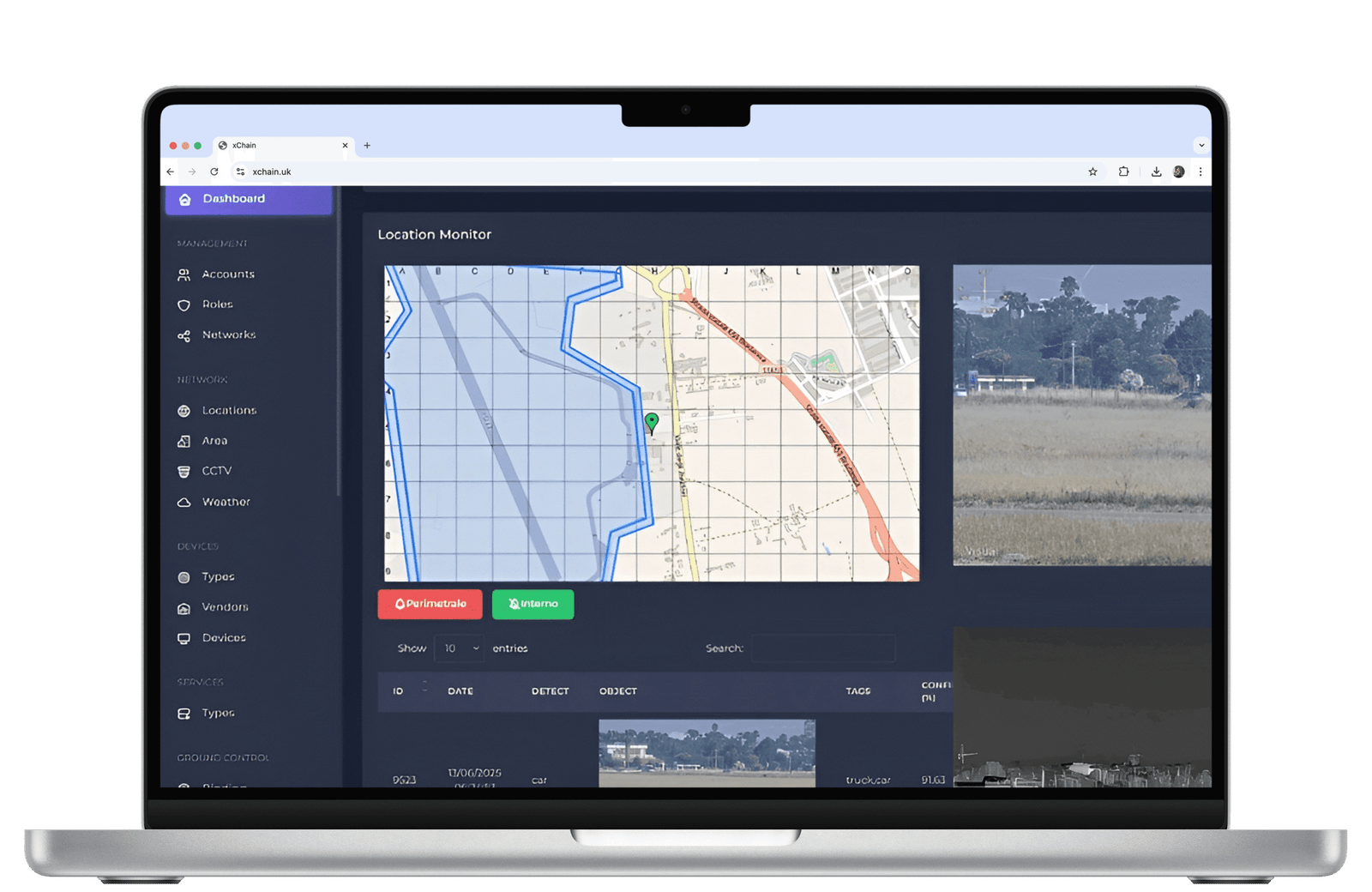
Airspace visibility
Ground ADS-B, live view, e-map tools, and 360° ground and air surveillance support stronger situational visibility for operators and infrastructure teams.
Weather and landing awareness
An all-in-one weather sensor with cloud height measurement, together with radar-assisted virtual landing plan analysis, supports better environmental understanding during flight-critical phases.
Tracking and detection
The datasheet references thermal tracking, intrusion detection with facial recognition, and detection of cooperative and non-cooperative drones around operational zones.
Protected event recording
Digital recording and a permissioned blockchain architecture are described as mechanisms for data integrity, auditability, and stronger resistance to spoofing or unauthorised tampering.
Remote control workflows
Satellite and terrestrial communications, data relay to remote control centers, and hybrid cloud supervision are part of the stated remote-operations model.
Infrastructure automation
Smart CT is described as supporting aircraft-triggered ground functions, including runway light activation from the cockpit via satellite, as well as electrical and electronic self-diagnosis of infrastructure elements.
Designed for helipads, vertiports, helicopters, tiltrotors, and eVTOL operations
Smart CT is described as a transportable, fast-to-install platform for connected landing operations, with a focus on operational readiness and controlled infrastructure environments.
- Suitable for helicopter and advanced air mobility environments
- Supports landing-zone visibility and remote operational control
- Includes digital recording and remote data relay
- Supports e-map, live view, and infrastructure status awareness
- Designed to strengthen the interface between aircraft and ground systems

Distributed operational architecture
Smart CT is framed as a networked ground-station environment capable of functioning as an automated Network Operation Center for connected aviation infrastructure.
Networked ground stations
Supports a distributed approach to monitoring, control, and data visibility across operational nodes.
Remote supervision
Hybrid cloud supervision and remote control center connectivity support enterprise oversight models.
Operational continuity
Event recording, remote relay, and resilient communications help create a stronger control framework for landing infrastructure.
Representative use cases
A cleaner, internationally neutral presentation of where Smart CT can be relevant.
Helipad operations
Supports take-off and landing visibility, weather awareness, and remote operational oversight for helicopter environments.
Vertiport readiness
Helps position infrastructure for future eVTOL operations through sensing, communications, and digital control workflows.
Air ambulance support
Relevant to emergency and medical aviation contexts where landing-phase situational clarity is operationally important.
Remote sites
Can support connected landing environments in locations where visibility, communications, and remote control functions are valuable.
Critical infrastructure
Suitable for sites requiring controlled access, event recording, operator visibility, and stronger infrastructure awareness.
Security-sensitive environments
Intrusion detection, facial recognition, and drone detection can support monitoring around controlled landing areas.
Frequently asked questions
Structured for clarity, discoverability, and answer-engine readability.
What is Smart Control Tower?
Smart Control Tower, or Smart CT, is a connected aviation infrastructure platform for helipads, vertiports, helicopters, tiltrotors, and eVTOL operations. It brings together sensing, communications, remote visibility, event recording, and infrastructure control in one system.
What technologies are described in the datasheet?
The datasheet mentions ground ADS-B, thermal tracking devices, an all-in-one weather sensor with cloud height, radar support for virtual landing plan analysis, digital recording, permissioned blockchain, remote control center relay, e-map, live view, intrusion detection with facial recognition, and drone detection.
Which environments can Smart CT support?
The product is described for helipads, vertiports, helicopters, tiltrotors, eVTOL aircraft, and related controlled landing infrastructure where visibility, communications, and remote oversight are important.
How does Smart CT support safety and security?
It is described as supporting safer landing and take-off operations through improved visibility, environmental awareness, intrusion detection, drone detection, digital event recording, and a permissioned blockchain model designed for stronger resistance to spoofing and unauthorised tampering.
Can Smart CT support remote operations?
Yes. The datasheet references satellite and terrestrial communications, hybrid cloud supervision, remote control center relay, and a networked operational model for connected infrastructure oversight.
Speak with Safe Fly Aviation
Discuss Smart CT deployment, helipad modernisation, vertiport readiness, or remote landing infrastructure requirements.